Description:
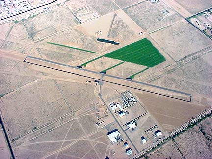
Listed as FAA identifier A39, this public-use airport is ultralight friendly. Formerly known at Phoenix Regional Airport (or PRA), it was purchased in 2007 by the Ak-Chin Indian Community. It can be hard to find as it is tucked away with few signs. But a nice place with great scenery and gorgeous mountains to the East. The airport also sells AVgas 100LL in self selvice pumps that are accessible 24 hours a day. It is almost always the least expensive in the state.
As with any new site, always talk to the local pilots for information on how to preserve and maintain an incredible site. The airport manager, Tim, is also very accomodating to all pilots. Here is some further information that is helpful. We use the giant grass area to the North of the main runway. If you do fly here, be mindful of the airspace, especially the paved runways, and the air over 600'. It is an active airport and it is a good idea to monitor air traffic on the UNICOM band 122.9. Do not drive or fly over or in front of the paved runways as the air traffic and airport operators are very sensitive to this. Also, stay clear of the residential areas on either end of the airport. Do not fly over any homes or livestock in the vicinity of the airport. Most of the nearby residents do not mind or enjoy aviation, but there are a a few residents that despise anything that flies.
Directions:
- Approach from the N (Phoenix):
- Take I-10 East to Tucson.
- Exit at Queen Creek Rd., turn right (West)
- Go 16 miles on Queen Creek Rd. which becomes Maricopa Rd. Arrive in town of Maricopa. Keep going past the sign for Hwy 238 North/Smith Enkie Road and keep driving for about a mile.
- At Maricopa-Casa Grande Hwy 238, turn left (SE). There is a small sign here, but also take notice of the blue NAPA AutoParts building and the silver train car on both corners. (N33-03.410 W112-02.876)
- Go about 8 miles on Maricopa-Casa Grande Hwy 238 past all the cows farms.
- At Anderson Rd., turn left (look for three, large, beige water towers on the corner) (N32-59.022 W111-55.749)
- After abut 200 feet, Anderson Road becomes a dirt road. Continue straight for about 1/2 mile.
- At Copperstate Road, turn right.
- Go about 1/2 mile down this road to the dirt field.
- Approach from the S (Casa Grande, Tucson):
- I-10 West to Phoenix
- Exit at I-8, turn left (West). Go about 4 to 5 miles on I-8.
- Exit at Thornton Rd, turn right (North). For about 4 to 6 miles.
- At Cottonwood Lane, turn left (West) at the interchange light.
- Go about 8 to 10 miles. Cottonwood will turn into Maricopa-Casa Grande Hwy 238 heading NorthWest. You will pass a Frito Lay plant on the right.
- At Anderson Rd., turn right (look for three, large, beige water towers on the corner) (N32-59.022 W111-55.749)
- After abut 200 feet, Anderson Road becomes a dirt road. Continue straight for about 1/2 mile.
- At Copperstate Road, turn right.
- Go about 1/2 mile down this road to the grass field.
Latitude: 32.995085 or 32°59.30'
Longitude: -111.921331 or -111°55.14'
Get Map of PRA
AirNav Flight Planning for A39